Sistan Basin in eastern Iran: A major dust source for south Asia
Characteristics of the Sistan Basin
The Sistan Basin in south-eastern Iran has been widely recognized as one of the most intense and active dust-storm regions in southwest Asia. Despite of this, it remains nearly unknown to the broad dust-aerosol community in India and the meteorological aspects that favour the dust outbreaks, the dust-plume pathways, the affected areas and the specific role of the Hamoun ephemeral lakes and the position and movement of the Inter-Tropical Convergence Zone (ITCZ) in dust activity need to be better examined and clarified. Sistan is a topographic low basin, located in south-eastern Iran along the borders with Pakistan and Afghanistan (Fig. 1). The northern part of the basin is covered by shallow (< 4m in depth) ephemeral lakes that are fed from the discharge of the Helmand river. During the hot dry summer season, the lakes get dried forming a saline surface and leaving an alluvial silt material that is very easily eroded by the strong northerly Levar winds (Rashki et al., 2013). The combination of the saline dried soil with the intense surface winds favours massive dust storms over the region, where PM10 concentrations of above 1000 µgm-3 have been recorded in Zabol (Rashki et al., 2012).
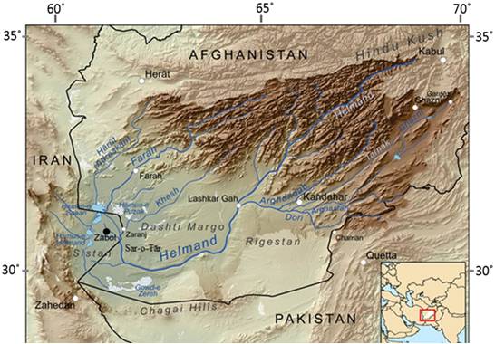
Figure 1: Topographic map of Hamoun Basin and Sistan region. The location of Zabol is indicated by the black circle (30° 57'N, 61° 34'E). The bold color in the map defines the Helmand drainage basin that fed Hamoun lakes complex. [Source: http://en.wikipedia.org/wiki/Sistan_Basin; Reproduction by Rashki et al. 2013].
The levar wind: Synoptic and dynamic meteorological aspects
Every year during the summer season (June-September), Sistan is under the influence of the intense Levar or "120-days" wind, which blows from northern directions with high velocity (~20 ms-1) in certain circumstances resulting in massive sand and dust storms. Regional Climate Model (RegCM4) simulations showed that the mountainous topography around Sistan creates a canal strengthening the northern winds, since sheltering and channelling are known to enhance the wind flow (Fig. 2). The wind profile shifts also to larger vertical gradient, with much higher values near the surface (950-900 hPa) and lower above 750 hPa (Fig. 3). The simulations also revealed a diurnal variation in the wind speed for levels below 800 hPa with maximum values during night time and early morning (18:00 and 00:00 GMT), when the nocturnal low-level jet is stronger.
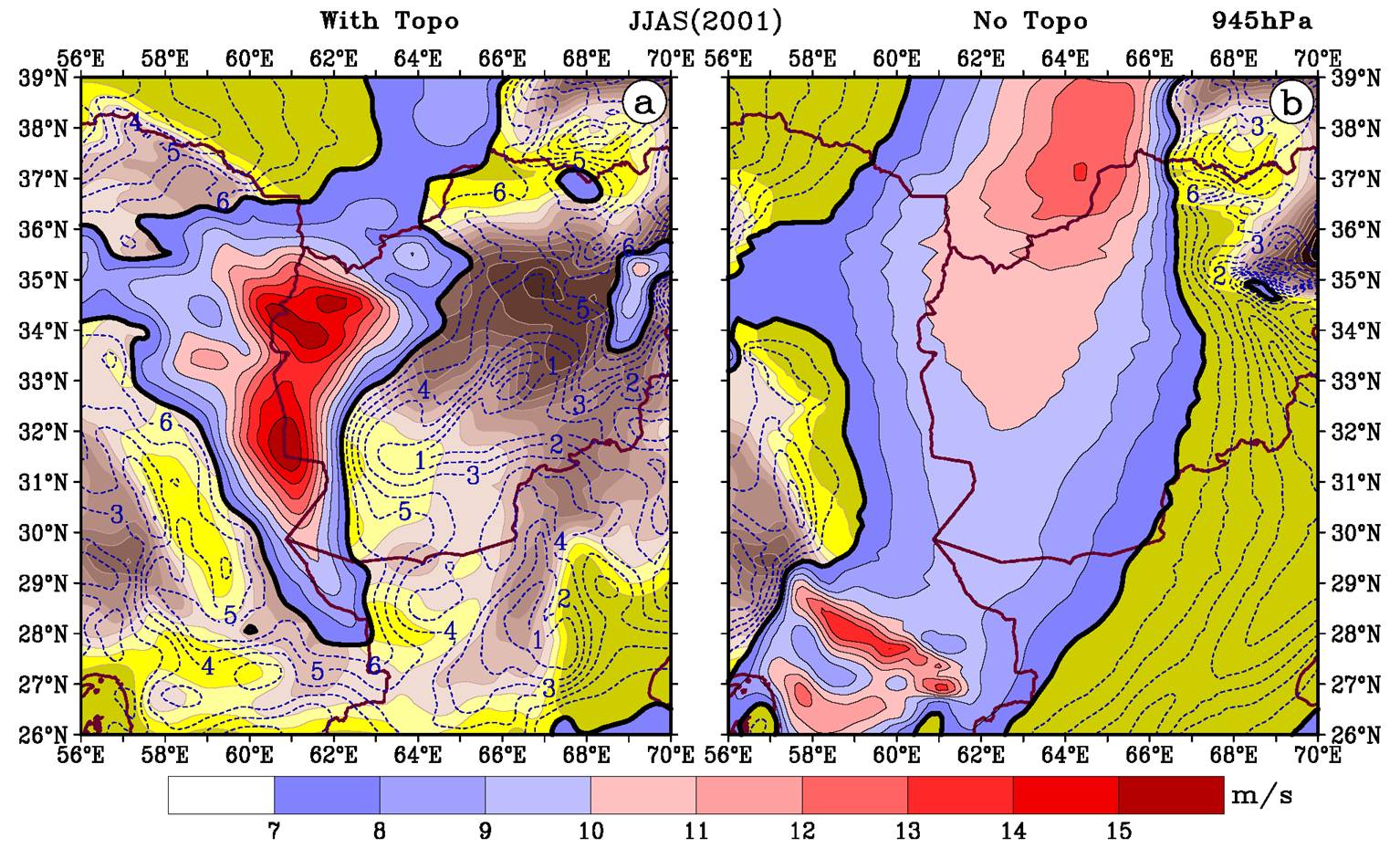
Figure 2: Seasonal (JJAS, 2001) mean wind velocity (ms-1) over Sistan and surroundings via RegCM4 simulations at 00:00 GMT (LST=GMT+3:30) with (a) and without (b) the underlying topography. The contours are in 1 ms-1 and values greater than 7 ms-1 are drawn [Reproduction by Kaskaoutis et al., 2014a].
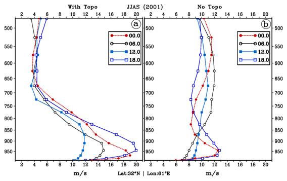
Figure 3: Seasonal (JJAS, 2001) mean vertical profiles of wind velocity (m s-1) over Sistan basin (32oN, 61oE, where the wind velocity is maximum) via RegCM4 simulations with (a) and without (b) underlying topography at 00:00, 06:00, 12:00 and 18:00 GMT (LST=GMT+3:30) [Reproduction by Kaskaoutis et al., 2014a].
A recent work by Kaskaoutis et al. (2014a) shed light on the synoptic and dynamic meteorological conditions associated with intense dust storms in Sistan. The intense dust storms correspond to daily-mean visibility records at Zabol of vis < 1 km following the World Meteorological Organization (WMO) and were found to be 356 during the summer months (June-September) of the period 2001-2012 with higher frequency in June (93) and July (111). Figure 4 shows the composite-mean maps for the Mean Sea Level Pressure (MSPL) and geopotential height at 700 hPa (Z700) obtained from the NCEP/NCAR database during the dust-storm days. At surface level, the cyclonic circulation over central Pakistan and north-western India along with the high pressure gradient between the Pakistan low-pressure center and the high-pressure regime over west-central Asia induce the strong northerly Levar wind, which is responsible for dust storms in the Sistan region. As the monsoon season progresses, the low pressure system weakens significantly and so does the dust activity over Sistan (Rashki et al. 2012). At 700 hPa, the ridge over Africa and Middle East combined with the trough over the Indian sub-continent induce a strong northerly flow (associated with the flow of the low-level jet) over Iran-Afghanistan-Pakistan borders.
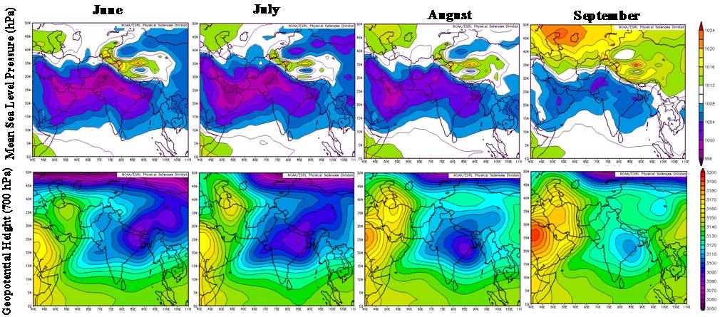
Figure 4: Composite-mean MSLP maps (upper panels) and Geopotential Height at 700 hPa (lower panels) of the dust-storm days over Sistan during the period 2001-2012 for the summer (JJAS) season [Reproduction by Kaskaoutis et al., 2014a].
Furthermore, the anomalies of the meteorological fields during the dusty days from the mean 30-year (1981-2010) NCEP/NCAR monthly climatology were studied aiming to reveal the meteorological patterns that favour the dust outflows from Sistan. Figure 5 provides the synoptic maps of the MSLP (above) and Z700 (below) anomalies of the dust-storm days during 2001-2012 from the climatology 1981-2010. The anomaly patterns are characterized by positive anomalies (enhancement) in the
